Interested in bicycling to work? Not sure which routes to take?
All Fort Collins and CSU bike trails can be found on Google maps. Follow the instructions below for routing to CSU trails:
Step 1 – Select directions button
- Select “Directions” to enter your start and end destination.

Step 2 – Select route preference
For this example, we’ve selected the Lake Street Garage to the Veterinary Teaching Hospital:
- Enter “Start address” – Enter the starting address with as much detail as possible (street, city, state, zip).
- Enter “Destination address” – Enter the destination address with as much detail as possible (street, city, state, zip)
- Select “…”- Click the three dots (“…”) to reveal other modes of transportation.

Step 3 – Select route preference
- Select bicycle icon – After more transportation modes are revealed, select “Bicycle.”
- Confirm address – Confirm that Google has accurately processed the addresses you entered.
- Select route – Select the route and click details. Select a route that meets yours bicycling style and time constraints. This screen capture depicts two routes (8 and 10 minutes).
- Visually confirm route – The route highlighted in “blue” is the selected route. The route highlighted in “grey” is unselected option. The user can click on either route to review details.
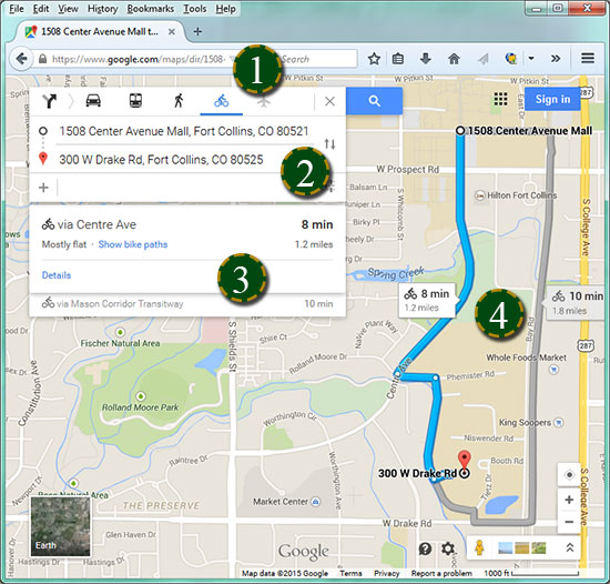
Step 4 – Review the route details
- Route summary – Review the distance and terrain evaluation of the route (in this case, “mostly flat, 1.2 miles, 8 min”).
- Review directions – Google Maps provides step-by-step written directions.
- Visually confirm route – Compare the selected route with the step-by-step written directions.
- Aerial image – Select the “Earth” button on the map to see an aerial view of the route to confirm landmarks.
