The city’s transit system, TransFort, tailors to neighborhoods with high concentrations of students and employees. This means our commuters have a reasonable walk to a transit stop from their home.
Most TransFort routes come directly to the Lory Student Center in the heart of campus. All students and employees can ride Transfort with their Ramcard. Here’s how you can find your closest transit stop along with the distance to walk:
Online Trip Planner
To plan your walk to a transit stop to catch the bus, visit http://www.ridetransfort.com/rider-tools/how-to-ride-transfort
- Enter your start address
- Enter your destination address
- Select your desired depart time and arrive time
- Select from the pull down menu:
- Best route (quickest)
- Fewer transfers
- Less walking
- Review the generated map for closest stop and walk distances
RideTransfort app
Visit RideTransFort.com or download the RideTransFort app to see how far the walk will be to your closest transit stop: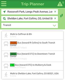
- Selecting the “Trip Planner” under the app menu, you can enter your to and from destinations. If you select “transit” as your mode of transportation, it will give you the walk distance to your closest transit stop to connect with the bus.
- Again, under “Trip Planner,” if you select “walking” as your mode of transportation, it will provide step-by-step driving directions.
The app is available in the iTunes and Google Play app stores.